On two limestone hills above the Seman valley, the arc of an Illyrian civilisation — from its first walls to its last bishop — is still legible in stone.
by Rabiela Myteveli (Fier)
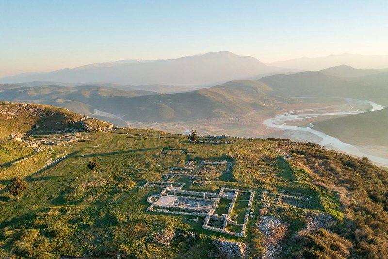
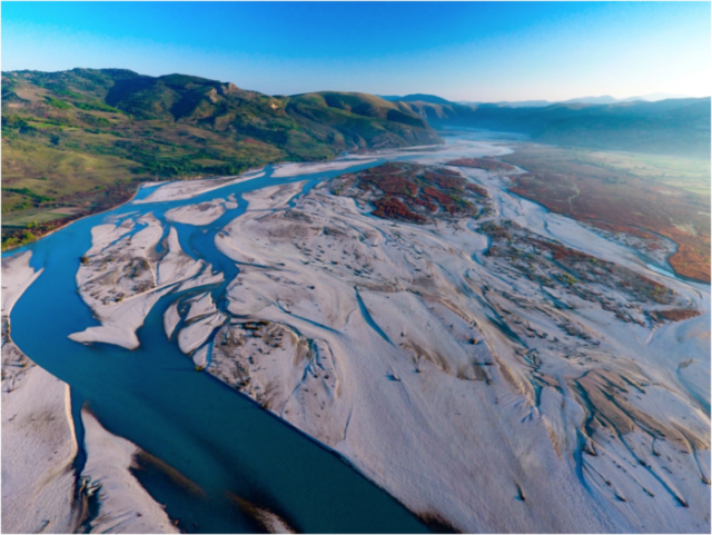
The walk from the parking area takes twenty-five minutes. The path climbs through scrub and dry grass, the hillside warming quickly in the morning sun, and for a while there is nothing to announce where you are going. Then the plateau opens. The valley below spreads in every direction — the Seman curving west, the Myzeqe plain fading into haze, the Adriatic a pale line at the edge of visibility. To the east, Tomori sits above the horizon like a fixed point.
You understand immediately why they built here. From this ridge in the Mallakastër hills, the Bylliones could watch the valley, control the routes that passed through it, and know — at a distance — who was coming and with what intention. Height was not just defence. It was knowledge.
A Federation Builds a Capital
The city of Bylis was founded around the second quarter of the 4th century BCE, not as a village that grew but as a deliberate act of political architecture. The Bylliones — an Illyrian federation whose territory stretched across the lower Vjosa valley — chose this plateau as their capital and built accordingly. The defensive walls, cut in the isodomic ashlar masonry that marks civic confidence rather than improvised urgency, stretched for over two kilometres around a plateau of roughly 30 hectares. Inside, the city was planned on a grid: streets running in parallel lines, insulae of housing blocks, public buildings placed where a city’s institutions belong.
The theatre seated 7,500 spectators. In a city of perhaps 10,000 to 15,000 at its height, that is an assembly space large enough for the community to gather as a political body, not merely as an audience. The koinon of the Bylliones — the federal council — met here. Decisions were made, disputes adjudicated, alliances announced. The prytaneion, where the magistrates sat; the agora, where goods and arguments changed hands; the arsenal, its octagonal columns still visible; the cisterns, cut six metres into the rock to collect and hold rainwater through the dry months. A city designed to sustain itself.
The federation minted its own coins in two series — one bearing the city’s name, one the tribe’s — an alternating use that reflected a political community sophisticated enough to distinguish between its urban centre and the wider territory it governed. Neoptolemus, the son of Achilles and legendary founder of the city according to Stephanus of Byzantium, appeared on the coinage. Whether the myth was believed or deployed, its presence on bronze tells you something about how the Bylliones thought of themselves: as heirs to a heroic past, with a right to be taken seriously.
The City That Survived by Being Useful
Bylis navigated the turbulent politics of the 3rd and 2nd centuries BCE with a pragmatism that served it better than resistance. Occupied briefly by Cassander of Macedon, then by the Illyrian king Glaukias, then absorbed into the sphere of Pyrrhus of Epirus — the city changed hands without being destroyed, because it was too strategically valuable to wreck. When Caesar’s army arrived in 49 BC, marching the route from Apollonia toward Macedonia, Bylis surrendered and became a military base. The calculation was the same each time: yield, remain, continue.
Augustus elevated it to a Roman colony — Colonia Iulia Augusta — and the city continued as it had, layering Roman infrastructure over Illyrian foundations. Bathhouses joined the grid. The theatre kept operating. The limestone blocks that had served the Bylliones now served Roman citizens who happened to live in the same city, on the same hill, using the same street plan.
What the Romans added in material comfort, the Byzantines added in spiritual weight. Under Justinian in the 5th century, several large Palaeochristian basilicas rose across the plateau — their floors covered in mosaics, their apses oriented east, their walls built from the same limestone as everything else. Bylis became a bishopric within the Eastern Orthodox Church. The city that had opened as an Illyrian political assembly closed as a seat of Christian ecclesiastical authority, the arc running from civic theatre to cathedral across eight centuries of continuous occupation.
In 586 AD, an incursion ended it. The population dispersed. The basilicas fell silent. The stone stayed on the hill.
The Prequel on the Next Ridge
A short distance away, on an adjacent hill, the site of Klos carries the story further back. Believed to have been the earliest urban centre of the Bylliones, with defensive walls that archaeologists date to the second half of the 5th century BCE, Klos predates Bylis by at least a century. It was here — on this rougher, earlier ridge — that the federation first took physical form, before the Bylliones had the resources or the ambition to build what they built at Bylis.
The two sites together are not a single city’s biography. They are a civilisation’s full sequence: the proto-urban origin on one ridge, the mature federal capital on the next, connected by a landscape that still reads, from above, as a coherent political territory. The joint archaeological park — designated Bylis-Klos — acknowledges what the topography has always made clear: these are not two separate sites but one story told across two hills.
What Is Being Done
The park has existed since 2003 but remained, for most of that time, under-visited and under-resourced — a site of genuine significance that the infrastructure had not yet caught up to. That is changing, slowly. A conservation plan for the Bylis-Klos park was approved in December 2025, developed through a partnership between Albania’s National Institute of Cultural Heritage and Italy’s development cooperation agency. A multifunctional visitor centre is in design. Local grants have gone to businesses in the Mallakastër area. Minister Gonxhja’s visit to the site this week — and his public framing of Bylis and Klos as evidence of a sophisticated ancient political order, not merely as ruins — signals an institutional commitment that the park has long deserved.
The signage is bilingual. The main paths are manageable. A small restaurant operates near the entrance.
Getting There
The park sits near the village of Hekal in Fier County, 9 kilometres off the Tirana–Gjirokastër national road. The walk from parking to site entrance takes around 25 minutes uphill. Admission is free on national and cultural holidays. Go in the morning. Bring water. The terrain is uneven and the sun, once the plateau opens, is unforgiving.The theatre has no roof. The cisterns are open to the sky. The mosaic floors of the basilicas are exposed to frost and summer heat, conserved where possible, worn where they are not. Bylis is not a reconstructed experience. It is the actual place, mostly intact, asking to be read on its own terms.
Eight centuries of a community deciding this hill was worth the effort of building on it. The effort shows.
The Bylis-Klos Archaeological Park is located near Hekal village, Fier County, approximately 9 km off the SH4 national road. Open year-round. Conservation project updates: bylisklos.al